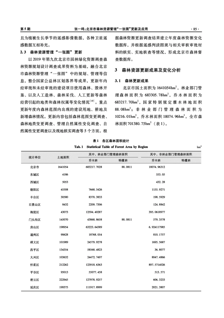
第52卷第5期2023年10月林业勘查设计ForestInvestigationDesignVol.52No.5Oct.2023北京市森林资源管理里“一张图”更新及应用张一鸣(北京市园林绿化规划和资源监测中心,北京100029)摘要:以2020年北京市森林资源管理“一张图”为基础,补充收集2021年造林绿化、森林采伐、森林疑似变化图斑、占用征收林地、森林灾害以及工程建设和其它规划调整等资料,结合高分辨率遥感影像变化地块判读分析结果和现场调查核实方法,对因改变土地用途增加和减少的森林地块以及森林范围内地类发生变化的森林地块,逐块调查核实,上图入库检查并更新森林地块的权属、森林类别、林种、工程类别等信息,形成北京市全市及各区森林资源管理“一张图”数据库。采用遥感判读区划与实地核实验证相结合的方法,尽快发现相关涉林案件并加大查处、督办整改力度,坚决遇制破坏森林资源的违法行为,保持北京市森林资源管理“一张图”的准确性、时效性,为规范北京市森林资源保护管理和森林督查等工作奠定基础。关键词:森林资源管理;遥感影像;“一张图”;森林督查;北京市中图分类号:S757.2;S758.61文献标识码:A文章编号:1673-4505(2023)05-0083-05UpdateandApplicationof“OneMap"forForestResourceManagementinBeijingZHANGYiming(BeijingLandscapePlanningandResourceMonitoringCenter,Beijing100029)Abstract:Basedonthe“OneMap"offorestresourcemanagementinBeijingin2020,supplementarydataonafforestationandgreening,forestlogging,suspectedchangesinforestpatterns,occupationofex-propriatedforestland,forestdisasters,engineeringconstruction,andotherplanningadjustmentsin2021werecollected,combinedwithhigh-resolutionremotesensingimageanalysisresultsandon-siteinves-tigationverificationmethods,investigateandverifyforestplotsthathaveincreasedordecreasedduetochangesinlanduse,aswellasforestplotsthathaveundergonechangesinforestscope.Theaboveimagewillbeusedtocheckandupdatetheownership,forestcategory,forestspecies,engineeringcategory,andotherinformationofforestplots,forminga“onemap”databaseforforestresourcemanagementintheentirecityandvariousdistrictsofBeijing.Bycombiningremotesensinginterpretationzoningwithon-siteverificationandverification,relevantforestrelatedcasescanbeidentifiedassoonaspossible...