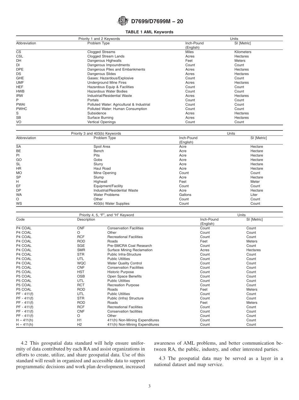
分享
ASTM_D_7699_-_D_7699M_-_20.pdf
下载文档

ID:172853

大小:95.07KB

页数:7页

格式:PDF

时间:2023-03-04

收藏 分享赚钱
温馨提示:
1. 部分包含数学公式或PPT动画的文件,查看预览时可能会显示错乱或异常,文件下载后无此问题,请放心下载。
2. 本文档由用户上传,版权归属用户,汇文网负责整理代发布。如果您对本文档版权有争议请及时联系客服。
3. 下载前请仔细阅读文档内容,确认文档内容符合您的需求后进行下载,若出现内容与标题不符可向本站投诉处理。
4. 下载文档时可能由于网络波动等原因无法下载或下载错误,付费完成后未能成功下载的用户请联系客服处理。
网站客服:3074922707
TM_D_7699_ _D_7699M_ _20
Designation:D7699/D7699M20Standard Practice forMinimum Geospatial Data for Abandoned Mine LandProblem Areas,Planning Units,Keyword Features,andProject Sites1This standard is issued under the fixed designation D7699/D7699M;the number immediately following the designation indicates theyear of original adoption or,in the case of revision,the year of last revision.A number in parentheses indicates the year of lastreapproval.A superscript epsilon()indicates an editorial change since the last revision or reapproval.1.Scope1.1 This practice covers the minimum elements for theaccurate location and description of geospatial data for definingAbandoned Mine Land(AML)ProblemAreas,Planning Units,Keyword Features,and Project Sites as originally defined bythe Office of Surface Mining Reclamation and Enforcement(OSMRE),through its Abandoned Mine Land InventoryManual(Directive AML-1)under the jurisdiction of SurfaceMining Control and Reclamation Act of 1977.These standardsremain applicable to mining organizations that geospatiallylocate and identify AML sites,however these standards can beused for entities that are in beginning phases of mapping andidentifying AML sites using protocol that is consistent withexisting nomenclature.1.1.1 Abandoned mine lands consist of those lands andwaters which were mined for coal or other minerals,or both,and abandoned or left in an inadequate condition of reclama-tion and for which there is no continuing reclamation respon-sibility for mitigation of adverse impacts to human health andsafety or environmental resources.1.1.2 As used in this practice,an AML Problem Area(PA)represents a closed polygon boundary for a uniquely definedgeographic area contained within an AML Planning Unit(PU).An AML PA is a subdivision of an AML PU that contains oneor moreAML keyword features together with impacted land orwater resources or both.An AML PA should not cross PUboundaries.1.1.3 As used in this practice,an AML PU represents aclosed polygon boundary of a uniquely defined geographic areaidentified by unique numbers and names.An entire WCU maybe delineated as a single PU or subdivided into multiple PUs.1.1.4 As used in this practice,an AML Keyword Feature isa point,line,or polygon defining the location of a specificon-the-ground feature contained within an AML Problem Area(PA)as described in the AML Inventory Manual.1.1.5 As used in this practice,an AML Project Site is aclosed polygon boundary for a uniquely defined geographicarea that includes the area disturbed to achieve the reclamation.An AML Project Site may contain one or more AML keywordfeatures together with impacted land or water resources orboth.1.2 UnitsThe values stated in either SI units or inch-pound units are to be regarded separately as standard.Thevalues stated in each system may not be exact equivalents;therefore,each system shall be used independently of the other.Combining values from the two systems may result in non-conformance with the standard.1.3 This standard does not purport to address all of thesafety concerns,if any,associated with its use.It is theresponsibility of the user of this standard to establish appro-priate safety,health,and environmental practices and deter-mine the applicability of regulatory limitations prior to use.1.4 This practice offers a set of instructions for performingone or more specific operations.This document cannot replaceeducation or experience and should be used in conjunction withprofessional judgment.Not all aspects of this practice may beapplicable in all circumstances.This ASTM standard is notintended to represent or replace the standard of care by whichthe adequacy of a given professional service must be judged,nor should this document be applied without consideration ofa projects many unique aspects.The word“Standard”in thetitle of this document means only that the document has beenapproved through the ASTM consensus process.1.5 This international standard was developed in accor-dance with internationally recognized principles on standard-ization established in the Decision on Principles for theDevelopment of International Standards,Guides and Recom-mendations issued by the World Trade Organization TechnicalBarriers to Trade(TBT)Committee.1This practice is under the jurisdiction of ASTM Committee D18 on Soil andRock and is the direct responsibility of Subcommittee D18.01 on Surface andSubsurface Characterization.Current edition approved Feb.1,2020.Published March 2020.Originallyapproved in 2011.Last previous edition approved in 2011 as D7699/D7699M 11.DOI:10.1520/D7699_D7699M-20.Copyright ASTM International,100 Barr Harbor Drive,PO Box C700,West Conshohocken,PA 19428-2959.United StatesThis international standard was developed in accordance with internationally recognized principles on standardization established in the Decision on Principles for theDevelopment of International Standards,Guides and Recommendations issued by the World Trade Organization Technical Barriers to Trade(TBT)Committee.

此文档下载收益归作者所有

下载文档
你可能关注的文档
收起
展开